Madeira
Maps Map Cartography
 Madeira Tour & Trail
Map 8th Edition in Map-Paper & Super-Durable
versions
Madeira Tour & Trail
Map 8th Edition in Map-Paper & Super-Durable
versions
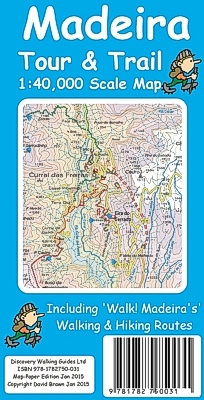
 8th edition
Map-Paper version £5.99 isbn 978-1782750031
8th edition
Map-Paper version £5.99 isbn 978-1782750031


8th edition Super-Durable version £8.99 isbn 978-1782750048
Super-Durable Map - 2 Year Guarantee
If you are using our latest 8th edition Tour & Trail Map with Walk! Madeira
and/or Shorley Whitehead's Madeira Walks see the 'Conversion
Table for your walking routes'.
Thanks to all the
walking research and road surveys carried out by Shirley and Mike Whitehead for
their new Madeira Walks volume 1 Leisure Trails and volume 2
Challenging Trails & High Altitude
Routes,
plus road updating survey we have been able to comprehensively update our digital
database to produce a new 8th Edition for 2015.
Significant changes include the new walking routes from Shirley's latest books
plus updates to the island's road network..
8th Edition of our Madeira Tour & Trail Map is
available in Super-Durable & Paper versions.
Our large 1:40,000 scale, combined with splitting the island into East and West
with a generous overlap, produces double sided map whose total size is 840mm by
600mm and folds to 235mm by 120mm.
You get the most detailed map of Madeira that is produced including our 'Tour &
Trail' level of detail ranging from major roads to secondary roads to minor
roads to streets and camino rural narrow country roads, plus dirt roads and
walking trails.
Altitude background colouring is designed to clearly show the altitude range
when travelling across the island by car or on foot. 100 metre and 50 metre
contours are clearly shown on the map along with a large number of individual
height points and all of the official 'Trig' points.
Tour & Trail attention to detail is legendary as is our useful symbol range
including miradors, picnic areas, petrol stations, bar/restaurants and parking
areas where you can pull off the road safely. You will easily identify springs,
caves, sports grounds, cemeterys, churchs, chapels, lighthouses, towers and
forts, camping areas, wind turbines, hotels etc.
For adventurers on foot Tour & Trail Maps are researched and designed by hikers
for use by hikers. Our comprehensive gps ground surveys produce the best road
mapping available but the value of this "on the ground research" becomes even
more important when you leave the tarmac. All of our DWG walking routes are
accurately gps surveyed giving you confidence in the accuracy of our Tour &
Trail Maps. Madeira Tour & Trail Map 8th edition includes all the walking routes
from 'Madeira Walks' volumes 1 & 2 by Shirley &
Mike Whitehead, also published in 2015.
It all adds up to the most useful map of Madeira that you can buy anywhere.
In use maps have a very tough life so you will appreciate our specialist
concertina map fold that allows you to quickly open the map, and more
importantly fold it back up to its pocket size after use.
Paper maps will always suffer from the repeated unfolding, folding to the
section you want to use, and then refolding. We recommend everybody to obtain
our Super-Durable editions printed with 100% oxygenation inks on Polyart by the
UK's leading map printer, which produces a map that feels like silk but will
stand up to the roughest treatment of outdoor adventuring and yet fold up like
new at the end of your adventure.
Tour & Trail Super-Durable Maps are more expensive than paper maps, but
represent better value.
Scale 1:40,000 2.5cms = 1km.
Total printed Map area 152 cms by 60 cms.
Map size double-sided 84 cm by 60 cm folded to 23cm by 12cm.
Roads; Motorway (Via Rapida), major roads, secondary roads, minor
roads & tarmacked lanes for all the
new roads and tunnels; including the new road numbering system.
Tracks & Trails; Unsurfaced (dirt) roads and walking trails.
Heights; 100 & 50 metre contours, height & trig points in
metres, height background colours in 200 metre colour bands.
Grid; 1 minute Latitude Longitude grid with WGS84 Datum.
Published Walking Routes; 'red dashed line' walking routes
'gps tracked' onto the map from
Madeira Walks
volumes 1 & 2
Madeira Tour & Trail Map 8th Edition Map-Paper version isbn 9781904946779 £5.99

Madeira Tour & Trail Map 8th Edition Super-Durable
version isbn 9781904946786
£8.99
 Tour & Trail Super-Durable Maps are printed on Polyart using 100% oxygenation
inks which produces a lightweight map that feels like silk while being both
water-proof and incredibly tough so that after even the toughest of adventures
your Tour & Trail Super-Durable Map will fold up like new. Polyart is made of
high-density polyethylene (HDPE) and is therefore 100% recyclable in category 2
HDPE.
Tour & Trail Super-Durable Maps are printed on Polyart using 100% oxygenation
inks which produces a lightweight map that feels like silk while being both
water-proof and incredibly tough so that after even the toughest of adventures
your Tour & Trail Super-Durable Map will fold up like new. Polyart is made of
high-density polyethylene (HDPE) and is therefore 100% recyclable in category 2
HDPE.
For more information see the Polyart website at http://www.polyart.com/en
Digital edition of
Madeira Tour & Trail Map available from


Put
Tour & Trail on your Garmin Custom Map editions of our Tour & Trail Maps
If you are using our latest 8th edition Tour & Trail Map
with Walk! Madeira and/or Shorley Whitehead's Madeira Walks
see the 'Conversion Table for your walking
routes'.
Madeira
Walks volume 1 Leaisure Trails
Madeira
2015 Bus &
Touring Map
Home, Titles, Madeira,
La Gomera, Mallorca, Menorca, Digital Cartography,