
 La Palma - Isla
Bonita
La Palma - Isla
Bonita
La Palma Walking
La Palma - Isla
Bonita
Regarded by many as the most spectacular
destination in the Canary Islands archipelago, La Palma has the
dramatic landscapes combined with an untouched feel which will
reward the discerning traveller. A dramatic mountain spine,
running from Roque de Los Muchachos (2426 metres altitude) down
the Cumbre Nueva to the Ruta Los Volcanes, splits the
island.
Walk! La Palma £12.99 144 pages
in full colour isbn 978-178275-0215
![]()
![]()
![]() Wordery
Wordery
new 3rd edition with Charles Davis and Jan Kostura See Latest Update for Las Coladas
de San Juan and Pico Birigoyo
The
steepest island in the world, the deepest crater, the clearest
skies: volcanoes you can climb without being shot into orbit; a
subtropical forest minus the slimy things slinking up your
trouser leg; black beaches, blue seas, high mountains, vegetation
that is literally flamboyant, everything linked by 1080
kilometres of waymarked paths; and all virtually untouched by
tourism.
If this sounds divine or like some lost paradise, you’re not
the first to think so, previous commentators have identified La
Palma as the prototype for both the Elysian Fields and Atlantis!
The fanciful stuff aside, the island is a walker’s idyll,
utterly tranquil, verdant and almost unspoiled.
Walk! La Palma
includes 37 fully detailed walking route itineraries.
Each walking route itinerary includes:-
- walking route summary
- ratings for Effort, Time, Distance, Ascents/Descents,
Refreshments and Vertigo risk
- fully detailed walk description, including frequent timings to
aid navigation and check your progress
- GPS Waypoints at every key point on every route where there is
good gps reception
- full colour 1:40,000 scale map of the route
- short walk and stroll alternatives
There are some easy routes. There are some challenging routes for
fit experts. With Charles Davis’ excellent walk descriptions
you’ll know which routes are for you - and all of them are a
true adventure.
In addition to the walking there is plenty of background
information along with details of accommodation, buses, official
walking routes, mountain biking, information offices etc complete
with web addresses, phone and fax numbers.
Walk! La Palma Specification & Contents
GPS navigation files, with Google Earth compatibility, now available for La
Palma - see PNFs
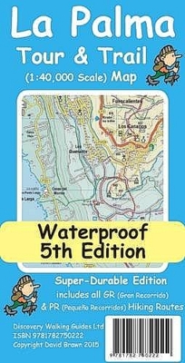
La Palma Tour & Trail
Super-Durable Map £8.99 isbn 978-178275-0222
Put Tour & Trail on your Garmin. Custom Map
editions of our Tour & Trail Maps
![]()
![]()
![]()

1:40,000 scale topographical map of La Palma now in Super-Durable edition.
As with the lesser known Canary Islands Walk! La Palma includes comprehensive information on accommodation (from hotels to hostals). Don't forget that La Palma is the 'wettest' of the Canary Islands, so pack a waterproof jacket in your backpack, and this frequently means that the mountains above 1400 metres are in cloud during the afternoon. Puerto Naos, on the west coast, is featured by some tour operators but is a long way from any walking trails and isolated compared to other accommodation options.
Digital edition of La
Palma Tour & Trail Map available from
![]()
![]()
Click on one of the links below to change pages:
Home Page Titles Gran Canaria La Gomera Tenerife Lanzarote Fuerteventura Walk! at Home-UK Walk! Abroad