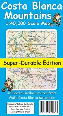
 Costa Blanca Mountains
Tour & Trail Super-Durable Map
Costa Blanca Mountains
Tour & Trail Super-Durable Map
Costa Blanca Mountains Tour Trail Map Spain
Costa Blanca Mountains
Tour & Trail Super-Durable Map
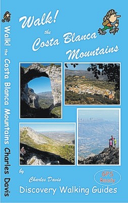 Thanks to all the walking research
carried out by Charles Davis for his new Walk! the Costa Blanca Mountains guide
book plus gps ground surveys carried out by David & Ros Brawn we have been able
to a new Costa Blanca Mountains Tour & Trail Super-Durable Map. This new Costa
Blanca Mountains Tour & Trail Super-Durable Map is the essential purchase for
everyone looking to explore the exciting mountainous hinterland on the Costa
Blanca. Whether you are exploring on foot, bike or horse this is your first
choice map for accurate navigation on roads and as soon as you leave the tarmac.
Thanks to all the walking research
carried out by Charles Davis for his new Walk! the Costa Blanca Mountains guide
book plus gps ground surveys carried out by David & Ros Brawn we have been able
to a new Costa Blanca Mountains Tour & Trail Super-Durable Map. This new Costa
Blanca Mountains Tour & Trail Super-Durable Map is the essential purchase for
everyone looking to explore the exciting mountainous hinterland on the Costa
Blanca. Whether you are exploring on foot, bike or horse this is your first
choice map for accurate navigation on roads and as soon as you leave the tarmac.
Scale 1:40,000 2.5cms = 1km. Map size; double-sided 780mm by 600mm folded to 21cm by 12cm. Roads; Motorway, major roads, secondary roads, minor roads & tarmacked lanes including latest road numbering system. Tracks & Trails; Unsurfaced (dirt) roads and walking trails. Heights; 100 & 20 metre contours, height & trig points in metres, height background colours in 200 metre colour bands. UTM 1km Grid with WGS84 Datum. Published Walking Routes; 'red dashed line' walking routes 'tracked' onto the map from the new Walk! the Costa Blanca Mountains. Costa Blanca Mountains Tour & Trail Super-Durable Map is printed on Polyart using 100% oxygenation inks by the UK's leading map printer so as to produce a map that is light but will withstand water and the harshest of weather to give years of service under the toughest of conditions. Still not convinced? Just ask anyone who has used a DWG Super-Durable Map, they'll soon tell you the advantages.
For adventurers on foot Tour & Trail Maps are researched and designed by hikers
for use by hikers. Our comprehensive gps ground surveys produce the best road
mapping available but the true value of this on the ground research becomes even
more important when you leave the tarmac.
All of our DWG walking routes are accurately gps surveyed giving you confidence
in the accuracy of our Tour & Trail Maps. Costa Blanca Mountains Tour & Trail
Super-Durable Map includes all the walking routes from Walk! the Costa Blanca
Mountains.
Tour & Trail Maps are produced in Super-Durable editions. We recommend everybody to obtain our Super-Durable editions printed
with 100% oxygenation inks on Polyart by the UK's leading map printer, which
produces a map that feels like silk but will stand up to the roughest treatment
of outdoor adventuring and yet fold up like new at the end of your adventure.
Super-Durable editions are 50% more expensive than Paper editions, but represent
better value. Quite simply Costa Blanca Mountains Tour & Trail Super-Durable Map
is the most detailed, accurate, toughest, large scale map of this exciting
region that you
can buy.
'Specialist Concertina map fold' makes Tour & Trail Maps easy to use, and more
importantly easy to fold back to their handy pocket size.
Whichever walking guide book you use, our Costa Blanca Mountains Tour & Trail Super-Durable Map is the map you should choose for adventuring in this most exciting of destinations.
Recent Review -
Erik Brockdorff Costa Blanca Mountains Tour & Trail Custom Map review
http://www.walking-holidays-in-spain.com
Over the last month my walking customers have been testing the Discoverywalking
sheet map and downloadable basemaps on the eTrek Garmin 20 GPS for the treks and
walking holidays we organise in the Costa Blanca Mountains.
The sheet maps are useful, although the 1:40,000 scale in the Spanish
countryside is at the limit for precise navigating, the roads on the map
translate as 55 metres wide on the ground – easily enough to get misplaced for a
while. Some of what appear as roads are overgrown dirt tracks that are now
footpaths, you can still get through but it can be a bit confusing so if you
want to go off the marked routes you will need to be patient.
The marking of existing official routes and recommended routes is very good,
there are some minor omissions and in one case replicating an error found on the
local 1:20,000 topo. Not perfect but a very good approximation and an
improvement on the local maps. The problem here is still the abysmal way marking
of routes on the ground.
The area covered is quite extensive, although some of my routes fall outside the
eastern margin of the coverage.
The basemaps for the Garmin GPS are very good, and they are now installed on all
my Garmins. The image is very clear, much better than my own 1:25,000 basemaps
that blur on zooming in.
The maps load relatively quickly on start-up and as you are walking the change
from one tile to another is very smooth, in fact it is barely perceptible.
All in all a great improvement for those of us who have been struggling with
Spanish maps for years, My only reservation is the 1:40,000 scale, I would love
it if you would considering publishing 1:20,000 or 1:25,000 maps as a future
upgrade.
Costa Blanca Mountains Tour & Trail
Super-Durable Map ISBN 9781904946847 £8.99 .
![]()
![]()
![]()

. . .
Digital edition of Costa Blanca
Mountains Tour & Trail Map available from
![]()
![]()
Put Tour & Trail on your Garmin. Custom Map
editions of our Tour & Trail Maps
Free Digital Custom Map edition click here for
details
Costa Blanca Mountains main page Alpujarras Menorca, Mallorca, Madeira, La Gomera, Titles DWG sitemap